
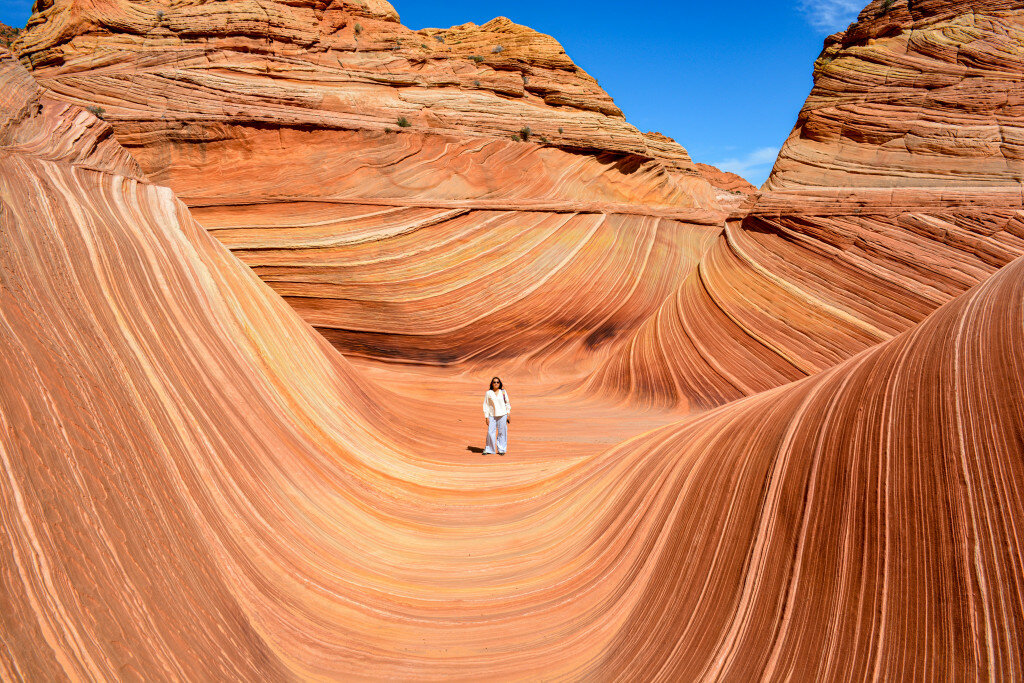
The hike to The Wave, located in the Coyote Buttes North Special Management Area of Pariah Canyon-Vermilion Cliffs Wilderness, requires a permit from the Bureau of Land Management, which are allocated by lottery and can be particularly difficult to get in the popular hiking month of May.
This item is available in full to subscribers.
To continue reading, you will need to either log in to your subscriber account, below, or purchase a new subscription.
Please log in to continue |
One morning last May, I was sitting in my kitchen in Page, Arizona, drinking coffee and trying to decide what I wanted to do on my birthday, which was two days away. For starters, I would be a no-show at work, which, of course, everyone should do on their birthday. The other plan that came to mind was riding my mountain bike from Big Water, Utah, to Alstrom Point in Glen Canyon National Recreation Area, a ride whose roundtrip distance would roughly approximate the age I would be turning – 56.
But I also thought it would be fun to spend the day hiking to The Wave, located in the Coyote Buttes North Special Management Area of Pariah Canyon-Vermilion Cliffs Wilderness. The catch was that the hike requires a permit from the Bureau of Land Management, which are allocated by lottery and can be particularly difficult to get in the popular hiking month of May. I decided to apply anyway and hope for the best. I’m generally not a lottery-winning type of person, so in the meantime, I started making a mental list of everything I would need to carry for a day-long mountain bike ride to Alstrom Point and back.
That evening I checked my email and, to my surprise, saw the congratulatory message from recreation.gov – I had scored a permit for me and my wife to The Wave. I logged into the website and confirmed that I would accept the permit. The next step was attending the mandatory orientation meeting the following morning in Page.
There were two other groups at the orientation: A 30-something couple from Prescott who had been trying for a Wave permit for four years, and four women from North Carolina, who mentioned that, coming from sea level, they could already feel the effects of Page’s 4,500-foot elevation while walking around town.
The orientation, led by a knowledgeable staff member at the Page Lake Powell Hub Visitor Center, offered safety advice for walking in the desert (carry 1 gallon of water per person, eat salty snacks, wear sunscreen), rules for hiking in the permit area (groups must stay together, walking sticks must be equipped with rubber tips to avoid damaging the rocks), and directions for the 3.2-mile hike from Wire Pass Trailhead to The Wave, since there is no marked trail through Coyote Buttes North. Hikers are given a cue sheet with numbered directions and photographs of geological formations to use as navigations aids.
Another bit of advice was to get an early start by arriving at the trailhead by dawn, which at that time of year was around 6:30 a.m. But according to the weather forecast, the temperature wouldn’t rise much above 80 degrees Fahrenheit throughout the day. Being residents of the Southwest, my wife and I often hike in hot weather, so we weren’t too concerned about getting a super-early start. We took the time to make pancakes for breakfast before embarking on the hour-long drive to the trailhead – west on Highway 89 for 36 miles, then south on unpaved, dusty, bumpy House Rock Road for 8.2 miles. We arrived around 8 a.m. Utah time, and there were already five or six cars in the parking lot, including the group from North Carolina.
We took our time getting started, making sure our water bottles and snacks were packed comfortably, applying sunscreen and signing the trail registry. As we set out along Coyote Wash, we were a few hundred feet behind the North Carolinians, but as we left the wash after about half a mile and started walking uphill, they stopped to rest. My wife and I paused to say hello as we passed, and they said they were starting to feel the effects of the elevation – around 5,000 feet at that point. They would be fine, though, just a little slower than they had anticipated. We would cross paths again at The Wave later in the day.
The rainy spring in the West had resulted in an abundant desert wildflower season, and although Coyote Buttes North is not particularly famous for its blooms, we did spot small clusters of reddish-orange Indian paintbrush, purple larkspur, and white and yellow primrose. At the same time, there hadn’t been much rain or wind during the previous two weeks, so the abundance of footprints made it easy to follow the unmarked “trail” as we crossed the sandy plain toward our next navigation point, a small saddle on a sandstone ridge on the horizon.
Once across the ridge, the terrain became rocky and uneven, with no footprints to follow. But we could see distinct geological formations in the distance for which we could aim. We saw no other hikers across the miles in front of us. The morning was sunny and cool as we traversed the landscape, the vast expanse of Pariah-Vermillion Cliffs Wilderness extending off to the left and Coyote Buttes rising sharply to our right.
Some of the slickrock formations looked like melted sherbet, others like jagged, knife-edged extrusions from the underworld. We skirted rocks that looked like colossal, scaled pinecones, and walked over others that we imagined could be the brains of petrified giants. The colors occurred in countless subtle variations of white, brown, yellow, red and green.
There was plenty to see, but hiking over the craggy, off-camber rocks also required paying attention to where we stepped. Anyone not accustomed to walking on terrain other than smooth trails or level sidewalks will find that they’re using leg and foot muscles they don’t normally use, which can make the hiking a bit more challenging and fatiguing than expected.
The most difficult part of the hike is the last steep sand embankment just before The Wave, which, with the loose, shifting soil, can feel like a game of one step forward, two steps back. Even when taken slowly and patiently, it can be a leg-burning aerobic workout.
At the top, just before entering The Wave, we encountered the first hikers we had seen since passing the North Carolina group – a couple with a pair of dogs who must have gotten an early start and were starting their trek back to the trailhead. With their departure, we had The Wave all to ourselves.
As the name suggests, the rock formation looks like brilliantly striated, undulating water frozen in time. Standing in its center was like being encased in a womb of flowing color. We stood there for a long time, simply absorbing the atmosphere and unexpected silence. Then we leapt into action, checking out angles and sightlines, and positioning ourselves for the obligatory flurry of photographs to post online and prove to the world that we had been there.
Our solitude lasted for about 30 minutes before the hikers behind us started arriving, at which point my wife and I headed deeper into the wilderness. There are several named geological features beyond The Wave for which hikers can aim – The Second Wave, Melody Arch, Top Rock Arch, The Alcove among them – but we didn’t have any destination in mind other than prolonging the hike and enjoying the colors, formations and views in every direction. Spending at least a few minutes exploring the area beyond The Wave is highly recommended for those who have the time and energy to spare. We spent about two hours walking a couple extra miles, taking photographs and simply sitting and basking in our surroundings.
By the time we headed back through The Wave, the North Carolina group had arrived and were engaged in their own photo-storm. My wife volunteered to take a group photo for them, which they greatly appreciated. We also met a woman in her 60s – a fit hiker from Kanab equipped with rubber-tipped walking sticks who was working as a volunteer checking permits and dispensing information about the area.
As we prepared to head back to our car, we encountered the couple from Prescott at the top of the steep, sandy slope just outside The Wave. They were accompanied by their three kids, all of whom had paused to empty the sand from their shoes. As we started down, we said hello to another couple who had stopped for a rest halfway up the steep slope. It’s not a long climb, but it can knock the wind out of those who try to go up too quickly.
Now that we were oriented to the area, on the return trip my wife and I wandered a bit from the straight-and-narrow path we had taken on the way to The Wave, checking out the expansive views to the east and exploring some side canyons to the west. We got passed by the volunteer from Kanab several times – she was hiking much faster than us, but she stopped several times to talk to groups that had started their hike later in the day and were still heading out toward The Wave.
Meanwhile, the afternoon temperature had crept into the low 80s, but a cool, moderate breeze kept the air feeling just about perfect for hiking. By the time we got back to the car, we had walked about 8 miles in 6.5 hours – four of that actually moving, according to the app I use to track my hikes, and the remaining 2.5 standing still and gawking at the landscape.
On the drive back to Page, I mulled the fact the hiking to The Wave didn’t mean I had lost the opportunity to pedal my mountain bike to Alstrom Point. I would be 56 for a whole year – plenty of time to tackle the ride.


