
Rainbow Bridge is a huge natural stone ridge in a remote part of southeastern Utah and is sacred to Native Americans. There are two ways to get to Rainbow Bridge: by boat and by foot.
This item is available in full to subscribers.
To continue reading, you will need to either log in to your subscriber account, or purchase a new subscription.
If you are a current print subscriber, you can set up a free website account and connect your subscription to it by clicking here.
If you are a digital subscriber with an active, online-only subscription then you already have an account here. Just reset your password if you've not yet logged in to your account on this new site.
Otherwise, click here to view your options for subscribing.
Please log in to continue |
NAVAJO MOUNTAIN and RAINBOW BRIDGE, Utah – Rainbow Bridge is a huge natural stone ridge in a remote part of southeastern Utah and is sacred to Native Americans. There are two ways to get to Rainbow Bridge: by boat and by foot. I recently went by foot with a full pack and with four other new friends.
William Howard Taft established Rainbow Bridge National Monument by presidential proclamation in May 1910. The national monument preserves a unique and impressively large natural bridge which has been known to Natives long before the arrival of Anglos to the Colorado Plateau.
It arcs across the sky as if a rainbow turned into a reddish-brown sandstone arch streaked with desert varnish. From its base to the top of the arch, it is 290 feet, nearly the height of the Statue of Liberty, and spans 275 feet across the arroyo.
Navajo stories tell of a male and a female rainbow deity coming together in perfect union and being frozen in time. This rock rainbow is particularly special because it looks like a rainbow from both sides, which is quite rare.
Everyone has a bucket list. Mine is still a work in progress and hiking to Rainbow Bridge was one of the items on that list.
A friend of mine announced one day on Facebook that they are organizing a backpacking trip to Rainbow Bridge and to let him know if anyone is interested in going. I immediately jumped at the chance. To hike to Rainbow Bridge, the party must have a Navajo Nation hiking permit. The group leader was in charge of that. The rest of us just had to get our packs ready and show up.
The date was set for late April. Five of us showed up at the rendezvous address and piled our heavy packs in the back of a friend’s pickup. As I hoisted my pack, an old school Kelty frame, I was glad it was not as heavy as usual. At 44 pounds with water, while lighter, still felt heavy.
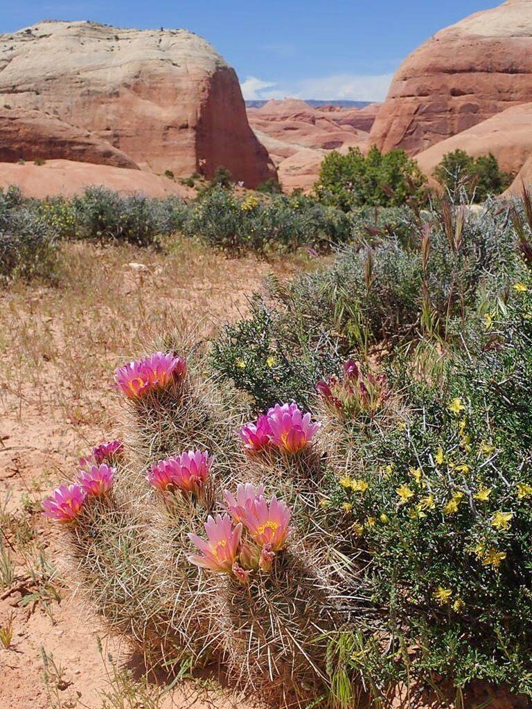
We drove some 100 miles to the trailhead on a day when the skies were clear and hardly a breeze was blowing. The wildflowers were highlighting the landscape with color as we approached the trailhead. After leaving the paved road, the roads weren’t marked and crisscrossed through the sandy and rocky landscape. Not for the faint of heart.
Our leader knew the way. Finally, we got to the trailhead and the view was already impressive. We had only a hint of what awaited us. Some in the group had been on the hike. The rest of us hadn’t.
The hike is not for the novice backpacker. While the net elevation drop from the trailhead to Lake Powell is around 2,200 feet, the hike has plenty of uphill to climb for respectable net elevation gain. The two longest steep climbs ended up easier than they looked from the bottom, even in the 80s heat.
Water is the crucial factor in deciding when to go. A person needs 4 liters of water to start the trip – the minimum for one day since it takes about a day to the first good water.
Some years, the streams dry up. This year, with the generous snows we didn’t have to worry about water. The trails were originally established by the Civilian Conservation Corps – a public work relief program that operated from 1933 to 1942 in the U.S. for unemployed, unmarried men – and could use a little tender loving care. The condition of the trails varied from just walking across a packed sand path to switchbacks that were covered with round rocks that tended to roll out from under the boots if not careful. Cairns were frequently well placed to make following the trail easy. Sometimes it seemed there were too many cairns. One of the hikers in our group successfully hiked the entire trail wearing well-made flip flops without injury! I swore that, after seeing her accomplish this feat, I wouldn’t make fun of another hiker in flip flops! To each their own! I’ll just use boots.
As we hiked up and down the trail, the beauty around us kept changing. From a distance, Navajo Mountain, which towers above Rainbow Bridge, doesn’t look all that jagged. The landscape unfolded with amazing rock formations, including fins and canyons. We didn’t have time to explore many nearby places and made a mental note to spend a day longer next time to allow for exploration. A look at the topo map shows a general east-west line of canyons, fins, and cracks.
Several hours later, and countless photos taken, our leader identifies our camp site for the night. It is on a high, flat area with a splendidly expansive view to the north.
In the distance rose the Henry Mountains. Between the Henrys and our camp, thousands of canyons and countless rock formations lie between. Water was about 1/2 mile away from camp. While plentiful, it still needed to be hauled to camp. I pulled out a featherweight cloth bucket-bag and filled it with about a gallon of water. One of the other hikers in our group and I shared the task of hauling this precious resource. We hung out by the campfire for a while, cooking steaks and potatoes in the coals, fresh swiss chard sautéed on a nearby backpacker’s stove rounded off the evening meal.
The next day was the longest, most challenging day. As a reward for our efforts, we were greeted with beauty at almost every turn. The wildflower blooms kept changing with new colors and shapes for each mile or two, rarely leaving an area flower-less. The ridges in the distance took shape as masses of sandstone fins cut by canyons. At seemingly each turn in the trail, the scenery just got better. The water kept being plentiful with a couple chances to top canteens as we hiked. We all had our water treatment systems and it isn’t advisable to drink untreated water.
At lunch we soaked our sore feet and basked in the sun. Some wandered off to a nearby sandstone dome. I focused on wildflowers and let my eyes take me around the area.
After lunch we continued to make our way to the ultimate goal of the trip: Rainbow Bridge itself. It was that afternoon I saw some trail retaining walls that likely dated back to the CCC days. Luckily the switchbacks were still there to allow climbing out of the canyons.
The scenery continued to lay itself out in front of us. We hiked over dome shaped rock, sandy washes, canyons, and down a crack, wide enough for a backpack which led to the main canyon: the canyon we would continue to follow tomorrow.
Tonight, the group stayed where they had stayed before, in a deep canyon with a flattish area to set up tents and kitchens.
As we set up the camp, we heard the sound of frogs croaking in the canyon. With the many alcoves carved out by the creek, the amphibians may have figured out how to amplify their sound by sitting in the sweet spot of an alcove. They were loud. I spent a long time listening to the sounds of nature at camp.
It has been a long, strenuous day and as I listened to the frogs, I was grateful for the opportunity to have gone on this hike. Grateful to have seen such incredible scenery. Grateful that nothing bad happened. Grateful for my new friends. The camp felt a lot like a river camp that one might find along the Colorado River or any of the other wet canyons of the Colorado Plateau. We hung out and talked for a while before fatigue took over and it was time to fall asleep, looking at the star-filled sky.
The last day proved to be the windiest. We packed up camp quickly and finished breakfast. We all knew that today would be the easiest backpacking day and the day we would see Rainbow Bridge. We had only three miles to cover and several hours until our rendezvous with another friend with a boat to take us back to Antelope Point Marina.
We hiked down the canyon. Not too far, one in our group noticed a small tub of water in the creek. Even though we hadn’t gone long, the idea of getting wet was enticing. Hesitating for a while, we finally decided to cool off. Good choice, I thought, as we carefully let ourselves into the water. The water was perfect. A little cold, to preclude sudden immersion, and didn’t take long to get used to. Wish we had known about it yesterday!
We continued following the trail and the canyon, stopping at the site of an old cowboy camp. Above the camp was a tall and deep alcove. Some in the group scrambled inside the alcove. Others just relaxed and enjoyed the scene. Throughout the hike, we saw various man-made structures. Some appeared to be Native sheep camps.
At last, the edge of the stone rainbow came into view. Just a portion of it but it was unmistakable. Before long, we crossed the fence with the National Park Service sign marking the official monument boundary. It had been a long time since I had seen Rainbow Bridge and never got to see it appear from the upstream, sunnier side. When so near, it doesn’t seem like the U.S. Capitol or even most of the Statue of Liberty could fit underneath, but I don’t doubt it.
I remember the day when it wasn’t a long walk from the boat dock to be able to get a view of the bridge. The waters of Lake Powell used to be under the bridge. Today, some thirty years later, the trail from the bridge is over a mile long and it seemed to be the longest of the entire trip.
We embraced the moment of being at Rainbow Bridge. The ravens were sailing through the canyon. The canyon flowed with water and formed a variety of pools. The winds had died down.
There were very few others. It was peaceful. As if blessed, we had beauty all around us for our entire trip. The Bridge is still impressive as ever. A near-perfect half circle connected on one side to a cliff.
Once on the boat, refreshments in hand, the ride was a bit bumpy with a lot of white caps on the water. Our friend’s boat cut through the water like a knife. The wind that woke us up this morning had just increased, foretelling a storm passing through. Luckily, we had excellent weather for the three days. The next day, it rained.


